
Humboldt and Arcata Bay during a 2021 king tide. | File photo by Tim Hanan.
###
Those of us who live in earthquake country tend to have two primary anxieties about the unsettling events: the shaking itself (collapsed roofs, crumbling buildings, etc.) and a tsunami (giant wall of water, ‘nuf said). However, a newly published study invites us to adopt an altogether new earthquake-related fear: rapidly sinking land.
The study, published Monday in the Proceedings of the National Academy of Sciences (PNAS), found that a major earthquake along the Cascadia subduction zone will likely cause between 1.6 and 6.5 feet of sudden subsidence long the Washington, Oregon and northern California coasts.
This abrupt land sinkage would dramatically raise the relative sea level of coastal communities in a matter of seconds. In the worst-case scenario, the subsidence would more than double the flooding exposure of coastal residents, structures and roads. And those risks would remain long after the shaking settles.
“This lesser talked about hazard is going to persist for decades or centuries after the earthquake,” the study’s lead author, Dr. Tina Dura, told NBC News. “The tsunami will come in and wash away and it’s going to have big impacts, don’t get me wrong, but the lasting change of the frequency of flooding … that’s going to have to be dealt with.”
Such damaging events have already happened elsewhere on the globe. Earthquake-driven coastal subsidence followed recent earthquakes in Chile, Alaska, Southeast Asia and Japan, resulting in such severe consequences as permanent land loss, widespread infrastructure damage and forced relocation.
These risks are exacerbated by climate-driven 21st century sea-level rise. In some communities along the coastal Washington, Oregon and northern California, the effects of sea-level rise are somewhat moderated by gradual coastal uplift. In fact, coastal uplift rates exceed the current rate of sea-level rise in such places as Astoria, Ore., Port Orford, Ore., and our neighbor to the north, Crescent City.
Humboldt Bay residents aren’t so lucky. Here, the study’s authors note, “complex regional tectonics are causing gradual subsidence, resulting in the highest recorded Pacific-coast RSLR [relative sea-level rise] rate of 4.7 [millimeters per year].” In other words, the ground beneath our feet is slowly dropping as the water rises.
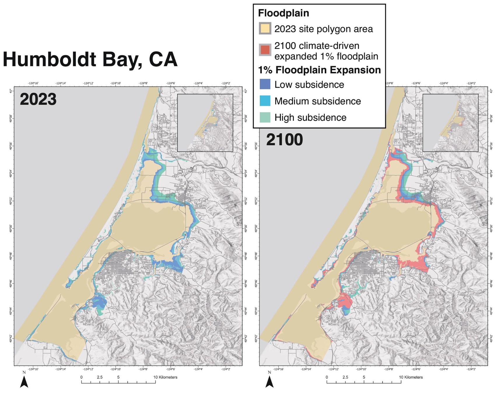

Floodplain map and bar graph depicting the expansion of the 1% floodplain (an area with a 1-in-100 chance of flooding each year) after earthquake-driven subsidence today (2023) and in 2100 when the earthquake-driven subsidence is amplified by climate-driven sea-level rise for Humboldt Bay. The bar graph shows the amount of land area, number of residents, structures, roads, and different land-use types in the 1% floodplain following earthquake-driven subsidence today (2023) and in 2100, when the effects of earthquake-driven subsidence are amplified by climate-driven sea-level rise. | Creative Commons license CC-BY-NC-ND 4.0.
###
The study defines a “major earthquake” as a magnitude 7.7 to 9.2, and while that may sound unlikely (knock wood), scientists were able to discover how often they occur by radiocarbon-dating plant fragments preserved within pre-earthquake peat or overlying mud. The results? There have been 11 such “great earthquakes” along Cascadia’s coasts over the past 6,000-7,000 years. They hit roughly every 200 to 800 years.
The most recent “great earthquake” along the Cascadia subduction zone struck in 1700 — more than 300 years ago. The CSZ is a major offshore fault line running from Northern California to British Columbia.
The authors of the new study warns that coastal flood hazard analysis often overlooks the risk of sudden earthquake-triggered land subsidence.
“This study underscores the need to consider combined earthquake and climate impacts in planning for coastal resilience at the Cascadia subduction zone and globally,” it says.
The combined effects of earthquake subsidence and climate-driven sea-level rise could more than triple the flood exposure of residents, structures and roads in the next 75 years, the study found. The coastal areas at risk are home to airports, major highways, wastewater treatment facilities, businesses and homes.
County leaders recently completed a Sea-Level Rise Adaptation Plan for Humboldt Bay/Eureka Slough Area. It advocates “an incremental approach” to planning, using various “shorter-term actions” to reduce immediate risk and buy time for more ambitious “longer-term actions” to address future conditions. It does not appear to contemplate the possibility of long-term projections becoming a reality all at once.
Tsunamis along the Cascadia Subduction Zone can be triggered in a mega earthquake when the Juan de Fuca plate is rapidly pushed underneath the North American plate, displacing massive amounts of water. That same movement can cause coastal land to suddenly drop, according to Dura, an assistant professor in geosciences at Virginia Tech.
If that happens, she recently told the San Francisco Chronicle, “All the sea-level rise you expected by 2300 is going to happen in minutes.”
You can download the study and read it for yourself via the link below. The study was funded by the Cascadia Region Earthquake Science Center, part of the National Science Foundation.
###
###
NOTE: This post was updated on April 29 to add the maps and bar graphs.
CLICK TO MANAGE