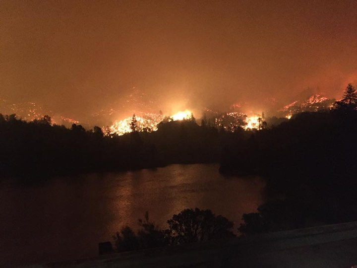
The Carr Fire as mapped yesterday.
The Carr Fire has once again nearly doubled in size, growing to 80,906 acres overnight.
“Firefighters worked aggressively through the evening to build containment lines around the Carr Fire,” Calfire reports. “Red Flag Warning and heat advisory are in effect for the area. The winds, high temperatures and dry vegetation still have the potential to fuel fire growth. Fire Spread has been active in all directions and has made significant runs.”
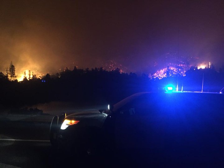
299 just east of Whiskey Creek. | Photos by Redding CHP.
New mandatory evacuations have been ordered as the fire continues to spread.
Mandatory Evacuation Orders:
- Community of French Gulch
- SR 299 west of Trinity
- Mountain Rd to the base of Buckhorn Summit
- Whiskey Creek Rd to include the boat launch/day use areas
- South along Swasey Dr from SR299 to Placer Rd
- West along Placer Rd from Swasey Dr to Prospect Dr
- North from Prospect Dr to encompass Middle Park Ranch Land Area
- West of Overhill Dr and North of SR 299
- North of SR 299 and West of Spinmaker Rd to the end of Harlan Dr
- Keswick Dam East to Counter Lane, North to quartz Hill Rd
- North of Sacramento River to Keswick Dam Rd, West of Market Street and Lake Blvd to Keswick Dam
- North at Lake Blvd and Oasis Rd to Pine Grove Ave and Walker Mine Rd west of Cascade Rd/ I-5
- Pine Grove Ave North on Lake Blvd to Shasta Dam incorporating Summit City, North Belt Line and Flannigan Rd
- Intersection of Placer Rd and Buenaventura Blvd west to Thompson Lane
- Buenaventura Blvd from Placer Rd to Westside Rd
- Westside Rd to Keyon Drive incorporating Country Heights and West Redding neighborhood
- Buenaventura Blvd to SR 299 to Placer Rd
- Placer Road from Buenaventura Blvd to Cloverdale Rd
- Cloverdale Rd from Placer Rd to Clear Creek Rd
- Clear Creek Rd West from Cloverdale Rd to Honey Bee Rd
- Shasta Dam Visitor Center All of Shasta Dam Blvd
- All of Shasta Lake City
- Placer Rd from the Clear Creek Bridge to Clear Creek Rd
- Placer Rd at Platina Rd to Buell Rd which includes South Fork Rd, Zogg Mine Road, Jenny Bird Lane, Horse Canyon Rd and all residents West of Platina Rd between Placer Rd and Buell Rd
- All areas on South Fork Road from Zogg Mine Rd to South Fork Road to include the areas of Bender Rd, Serenity Dr and Serenit Way
#CarrFire [update] off Hwy 299 and Carr Powerhouse Rd, Whiskeytown (Shasta County) is now 80,906 acres and 5% contained. NEW MANDATORY EVACUATION ORDERS IN PLACE. Unified Command: @CALFIRESHU and Whiskeytown National Park. https://t.co/QmhauhZj9m pic.twitter.com/RSwzyvF0jY
— CAL FIRE (@CAL_FIRE) July 28, 2018
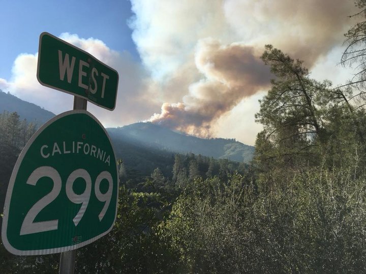
299 west of Whiskeytown Visitor Center.
Road Closures:
- Ashby Road & Lake Blvd
- Beltline at Oasis
- Benton & Quartz Hill Road
- Buckhorn Summit at SR 299 (Eastbound)
- Buenaventura at Keswick
- Buenventura & Hwy 299
- Caterpillar at Market
- Clear Creek Road & Cloverdale Lane Hwy 299 at Buckhorn Summit
- Elk Dr at Carnelian
- Eureka Way at Court Street
- Gas Point at Clear Creek Rd
- Iron Mountain Rd at SR 299
- Keswick Dam Boulevard at Keswick Dam Facility
- Keswick Dam Road & Quartz Hill Road
- Lake at Keswick
- Lake at Oasis
- Lake at Quartz Hill
- Lower Springs Rd at Swasey Drive
- Market at Lake
- North Market South of Lake
- North Point at Redwood
- Oasis Road & Lake Blvd
- Placer at Buenaventura
- Placer at Mule Town
- Planting Road & Gas Point Road
- Railroad at Buenaventura
- Ridge Lane at SR 299
- Riviera at Howard
- SR 299 from Buenaventura Boulevard to Buckhorn Summit
- SR-273 at Bonnyville
- SR-273 at Branstetter
- SR-273 at Breslauer
- SR-273 at Clear Creek
- SR-273 at Kenyon
- SR-273 at Westside Rd
- Sway Drive & Placer Road
- Texas Springs at Placer
- Texas Springs Road & Honeybee Road
Governor Jerry Brown has declared a State of Emergency in the area on Thursday, allowing for 3,410 firefighters, 328 engines, 62 water tenders, 17 helicopters, 67 hand crews, 62 dozers and numerous firefighting air tankers from all over the state to battle the blaze.
Two firefighters have been killed during the blaze, and an untold number of people have been injured.
500 Structures have been destroyed and another 4,978 are still threatened.
The fire is 5 percent contained.
299 at Oak Bottom
###
PREVOIUSLY:
- Fire Closes Highway 299; No Estimated Time of Reopening
- (TUESDAY AFTERNOON UPDATE) Highway 299 Still Fully Closed Due to Carr Fire
- REDDING IN DANGER: Carr Fire Explodes Overnight; Evacuations; Homes, Boats Destroyed; Road Closures
- ‘Unhealthy’ Air-Quality Conditions Possible Along Northern Interiors of Humboldt, Del Norte and Trinity Counties This Evening as Fires Rage in California, Oregon
- Governor Brown Declares State of Emergency for Shasta County Amid 20,000-Acre Carr Fire
- (VIDEOS) Redding Residents Document Their Carr Fire Experiences on Snapchat
- (UPDATING) Emergency Evacuations Ordered as Carr Fire Jumps Sacramento River; Fire is Burning ‘Very Rapidly Toward West Redding’
- (VIDEO) Calfire: Private-Hire Dozer Operator Killed By Carr Fire; Additional Firefighters, Civilians Injured
- FRIDAY MORNING CARR FIRE UPDATE: Two People Dead, Thousands Evacuated as Wildfire Burns West Redding
- How You Can Help Victims of Shasta County’s Carr Fire
- (VIDEO) Drone Captures Images of Redding Neighborhoods Destroyed by Carr Fire
- Redding Firefighter Who Died Battling Carr Fire Named
CLICK TO MANAGE